Goring batters Batanes, Signal no. 1 up in 4 areas | ABS-CBN
ADVERTISEMENT

Welcome, Kapamilya! We use cookies to improve your browsing experience. Continuing to use this site means you agree to our use of cookies. Tell me more!
Goring batters Batanes, Signal no. 1 up in 4 areas
Goring batters Batanes, Signal no. 1 up in 4 areas
ABS-CBN News
Published Aug 25, 2023 06:10 AM PHT
|
Updated Aug 25, 2023 12:45 PM PHT
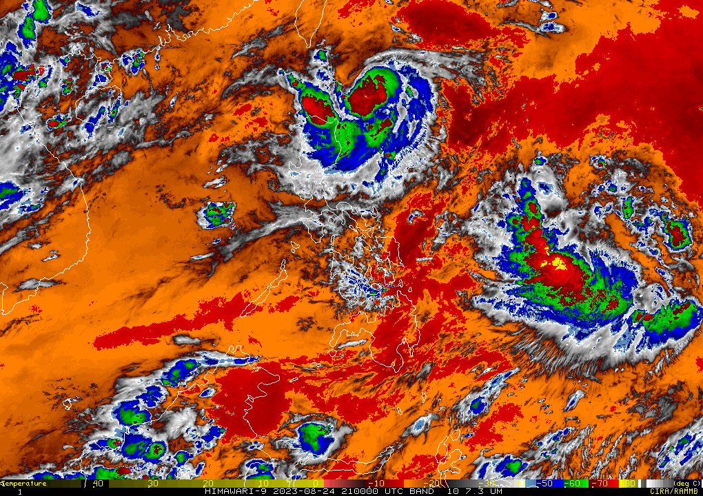
Tropical storm Goring (Saola) has slightly intensified near Batanes Friday morning while another cyclone has been spotted near the Philippine area of responsibility.
Tropical storm Goring (Saola) has slightly intensified near Batanes Friday morning while another cyclone has been spotted near the Philippine area of responsibility.
As of 4 a.m. Friday, Goring was estimated based on all available data at 220 km east southeast of Basco, Batanes with maximum sustained winds of 75 km/h near the center and gusts of up to 90 kph.
As of 4 a.m. Friday, Goring was estimated based on all available data at 220 km east southeast of Basco, Batanes with maximum sustained winds of 75 km/h near the center and gusts of up to 90 kph.
The storm is moving southwestward slowly, weather bureau PAGASA said.
The storm is moving southwestward slowly, weather bureau PAGASA said.
TCWS No.1 remains hoisted in the following areas:
TCWS No.1 remains hoisted in the following areas:
ADVERTISEMENT
- Batanes
- the eastern portion of Babuyan Islands (Babuyan Is., Camiguin Is.),
- the eastern portion of mainland Cagayan (Santa Ana, Gonzaga, Lal-Lo, Gattaran, Baggao, Peñablanca),
- northeastern portion of Isabela (Maconacon, Divilacan, Palanan)
- Batanes
- the eastern portion of Babuyan Islands (Babuyan Is., Camiguin Is.),
- the eastern portion of mainland Cagayan (Santa Ana, Gonzaga, Lal-Lo, Gattaran, Baggao, Peñablanca),
- northeastern portion of Isabela (Maconacon, Divilacan, Palanan)
Batanes, Babuyan Islands, and the northeastern portion of mainland Cagayan are forecast to receive 50-100 mm rainfall on Friday.
Batanes, Babuyan Islands, and the northeastern portion of mainland Cagayan are forecast to receive 50-100 mm rainfall on Friday.
The trough of tropical storm Goring will bring cloudy skies with scattered rainshowers and thunderstorms in Cagayan Valley, Cordillera Administrative Region, and Ilocos Region, which could cause possible flooding or landslides due to moderate with at times heavy rains.
The trough of tropical storm Goring will bring cloudy skies with scattered rainshowers and thunderstorms in Cagayan Valley, Cordillera Administrative Region, and Ilocos Region, which could cause possible flooding or landslides due to moderate with at times heavy rains.
Meanwhile, another tropical cyclone has been spotted outside PAR.
Meanwhile, another tropical cyclone has been spotted outside PAR.
As of 3 a.m., Tropical storm Damrey was estimated at 3,065 kilometers east of Northern Luzon. Packing 65 kph winds and gusts of up to 80 kph, the storm is moving east northeast at 35 kilometers per hour.
As of 3 a.m., Tropical storm Damrey was estimated at 3,065 kilometers east of Northern Luzon. Packing 65 kph winds and gusts of up to 80 kph, the storm is moving east northeast at 35 kilometers per hour.
Meanwhile, the southwest monsoon is expected to affect Central and Southern Luzon, Visayas, and Mindanao.
Meanwhile, the southwest monsoon is expected to affect Central and Southern Luzon, Visayas, and Mindanao.
Palawan, Occidental Mindoro, Zambales, and Bataan will experience
cloudy skies with scattered rainshowers and thunderstorms due to the habagat.
Palawan, Occidental Mindoro, Zambales, and Bataan will experience
cloudy skies with scattered rainshowers and thunderstorms due to the habagat.
Metro Manila and the rest of the country will experience partly cloudy to cloudy skies with isolated rainshowers or thunderstorms.
Metro Manila and the rest of the country will experience partly cloudy to cloudy skies with isolated rainshowers or thunderstorms.
ADVERTISEMENT
ADVERTISEMENT


