Storm Florita barrels toward northern Luzon | ABS-CBN

Welcome, Kapamilya! We use cookies to improve your browsing experience. Continuing to use this site means you agree to our use of cookies. Tell me more!
News
Storm Florita barrels toward northern Luzon
Storm Florita barrels toward northern Luzon
ABS-CBN News
Published Aug 23, 2022 12:18 AM PHT
|
Updated Aug 23, 2022 11:56 AM PHT
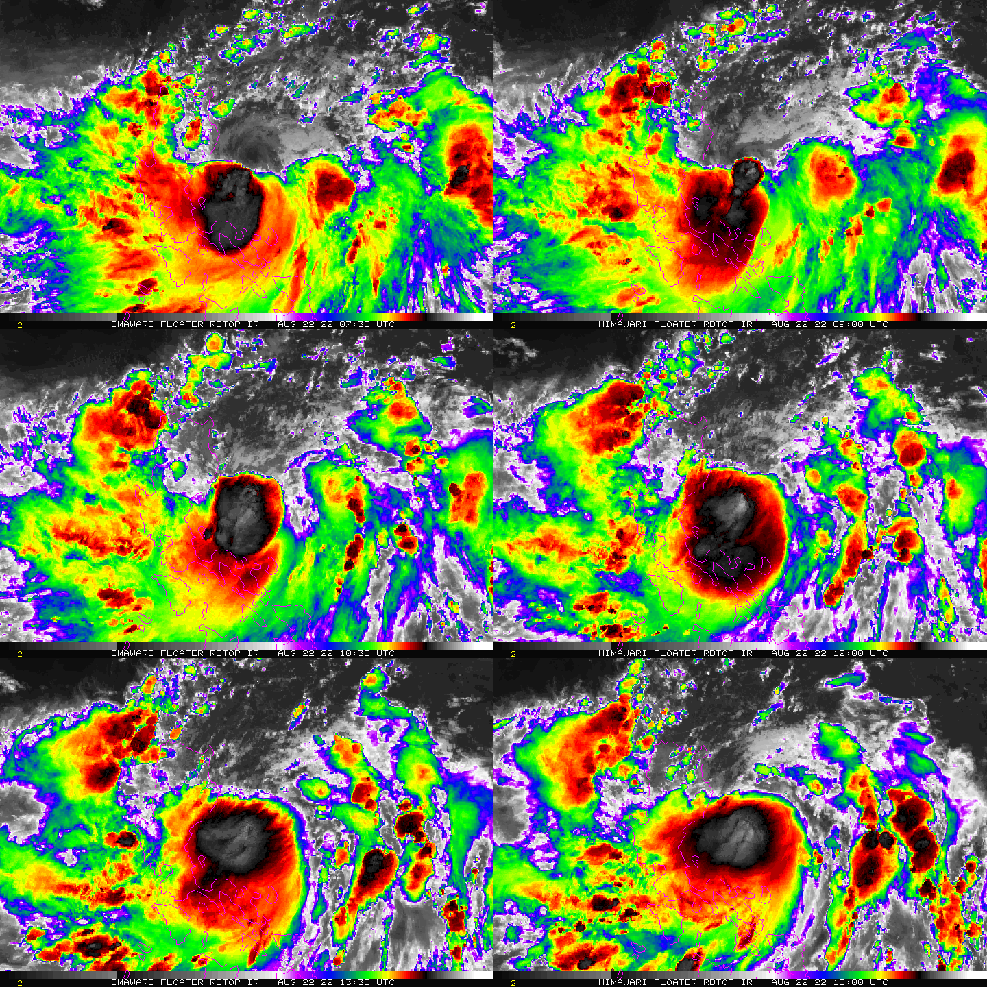
MANILA - Tropical Storm Florita (international name: Ma-on) slightly intensified as it continues to move westward, state weather bureau PAGASA said Monday night.
MANILA - Tropical Storm Florita (international name: Ma-on) slightly intensified as it continues to move westward, state weather bureau PAGASA said Monday night.
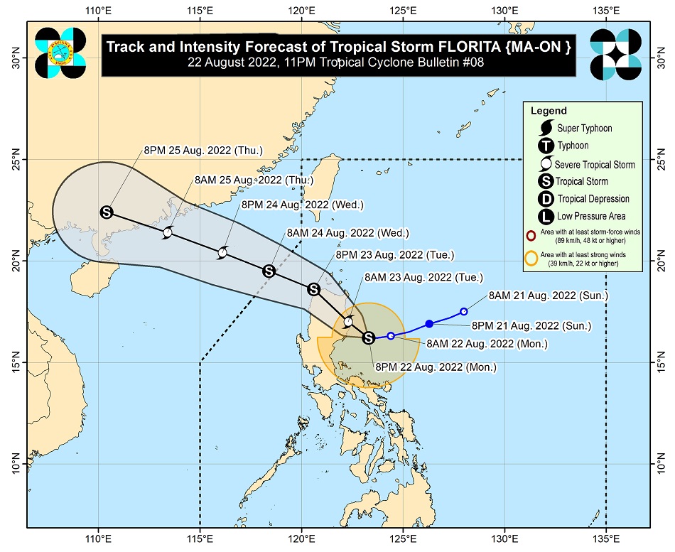
In its 11 p.m. bulletin Monday, PAGASA said Florita was last located 125 kilometers east of Casiguran, Aurora, packing maximum sustained winds of 85 kilometers per hour near the center, with gusts of up to 105 kph.
In its 11 p.m. bulletin Monday, PAGASA said Florita was last located 125 kilometers east of Casiguran, Aurora, packing maximum sustained winds of 85 kilometers per hour near the center, with gusts of up to 105 kph.
It was slowly moving westward.
It was slowly moving westward.
PAGASA said Signal No. 2 is currently hoisted over the following areas:
PAGASA said Signal No. 2 is currently hoisted over the following areas:
ADVERTISEMENT
- Cagayan
- Southern portion of Babuyan Islands (Camiguin, Fuga, Dalupiri, Pamuktan, Barit, Mabag, Irao islands)
- Isabela
- Quirino
- Eastern and central portions of Nueva Vizcaya (Kayapa, Ambaguio, Solano, Villaverde, Bagabag, Diadi, Quezon, Bayombong, Bambang, Aritao, Dupax del Sur, Dupax del Norte, Kasibu, Alfonso Castaneda)
- Apayao
- Abra
- Kalinga
- Mountain Province
- Ifugao
- Northern portion of Benguet (Bakun, Kibungan, Buguias, Kabayan, Mankayan, Bokod, Atok)
- Ilocos Norte
- Ilocos Sur
- Northern and central portions of Aurora (Dilasag, Casiguran, Dinalungan, Dipaculao, Baler, Maria Aurora)
Areas under Signal No. 2 may experience gale-force winds within the next 24 hours. The strong winds can peel off old roofs and tilt or down wooden electric posts, and damage banana plants, rice, corn, and trees.
Areas under Signal No. 2 may experience gale-force winds within the next 24 hours. The strong winds can peel off old roofs and tilt or down wooden electric posts, and damage banana plants, rice, corn, and trees.
Meanwhile, Signal No. 1 was raised over the following areas, where strong winds are prevailing or expected within the next 36 hours:
Meanwhile, Signal No. 1 was raised over the following areas, where strong winds are prevailing or expected within the next 36 hours:
- Rest of Babuyan Islands
- Rest of Nueva Vizcaya
- Rest of Benguet
- La Union
- Eastern and central portions of Pangasinan (Bani, Bolinao, City of Alaminos, Anda, Sual, Labrador, Bugallon, Aguilar, Mangatarem, Urbiztondo, Bayambang, Bautista, Alcala, Santo Tomas, Rosales, Balungao, Umingan, San Quintin, Natividad, San Nicolas, Tayug, Santa Maria, Asingan, San Manuel, Sison, Binalonan, City of Urdaneta, Villasis, Laoac, Pozorrubio, San Fabian, San Jacinto, Manaoag, Mapandan, Mangaldan, Santa Barbara, Malasiqui, Dagupan City, Calasiao, San Carlos City, Basista, Binmaley, Lingayen)
- Eastern portion of Tarlac (San Clemente, Camiling, Moncada, San Manuel, Anao, Santa Ignacia, Gerona, Paniqui, Ramos, Pura, Victoria, La Paz, City of Tarlac, Concepcion)
- Nueva Ecija
- Rest of Aurora
- Eastern portion of Pampanga (Magalang, Arayat, Candaba)
- Eastern portion of Bulacan (San Ildefonso, San Miguel, Doña Remedios Trinidad, San Rafael, Angat, Norzagaray, City of San Jose del Monte)
- Eastern portion of Rizal (Rodriguez, San Mateo, City of Antipolo, Tanay, Baras)
- Northern portion of Quezon (General Nakar, Infanta, Real, Mauban, Perez, Alabat, Quezon, Calauag) including Polillo Islands
- Northern portion of Laguna (Santa Maria, Famy, Siniloan, Pangil, Pakil, Paete)
- Camarines Norte
PAGASA said heavy to intense with at times torrential rains may prevail over Cagayan, Isabela, Cordillera Administrative Region, Ilocos Region, and Zambales, while moderate to heavy with at times intense rains may be experienced over Camarines Norte, Camarines Sur, Aurora, Quezon, Bataan, and the rest of Cagayan Valley until Tuesday.
PAGASA said heavy to intense with at times torrential rains may prevail over Cagayan, Isabela, Cordillera Administrative Region, Ilocos Region, and Zambales, while moderate to heavy with at times intense rains may be experienced over Camarines Norte, Camarines Sur, Aurora, Quezon, Bataan, and the rest of Cagayan Valley until Tuesday.
Light to moderate with at times heavy rains are also expected over Metro Manila, CALABARZON, and the rest of Central Luzon.
Light to moderate with at times heavy rains are also expected over Metro Manila, CALABARZON, and the rest of Central Luzon.
From Wednesday, heavy to intense with at times torrential rains may persist over Ilocos Region, Benguet, and Abra, while moderate to heavy with at times intense rains may be experienced over the rest of Cordillera Administrative Region.
From Wednesday, heavy to intense with at times torrential rains may persist over Ilocos Region, Benguet, and Abra, while moderate to heavy with at times intense rains may be experienced over the rest of Cordillera Administrative Region.
Light to moderate with at times heavy rains are also expected over Cagayan Valley.
Light to moderate with at times heavy rains are also expected over Cagayan Valley.
The southwest monsoon, on the other hand, is expected to bring monsoon rains over western Visayas, Mimaropa and the rest of Bicol region in the next 24 hours.
The southwest monsoon, on the other hand, is expected to bring monsoon rains over western Visayas, Mimaropa and the rest of Bicol region in the next 24 hours.
Under these conditions, scattered to widespread floods, including flash floods and rain-induced landslides may be experienced in flood and landslide prone areas.
Under these conditions, scattered to widespread floods, including flash floods and rain-induced landslides may be experienced in flood and landslide prone areas.
PAGASA said Florita is expected to continue moving westward before turning west-northwest early Tuesday.
PAGASA said Florita is expected to continue moving westward before turning west-northwest early Tuesday.
It is expected to make landfall near the east coast of Isabela or east coast of Cagayan Tuesday morning.
It is expected to make landfall near the east coast of Isabela or east coast of Cagayan Tuesday morning.
After landfall, the storm is expected to hit several provinces in northern Luzon before emerging over the West Philippine Sea by Tuesday night or early Wednesday morning.
After landfall, the storm is expected to hit several provinces in northern Luzon before emerging over the West Philippine Sea by Tuesday night or early Wednesday morning.
Florita may further intensify into a severe tropical storm prior its landfall, PAGASA said.
Florita may further intensify into a severe tropical storm prior its landfall, PAGASA said.
But it may slightly weaken after landfall as it traverses northern Luzon due to the frictional effects of the rugged terrain.
But it may slightly weaken after landfall as it traverses northern Luzon due to the frictional effects of the rugged terrain.
“Considering these developments, the public and disaster risk reduction and management offices concerned are advised to take all necessary measures to protect life and property. Persons living in areas identified to be highly or very highly susceptible to these hazards are advised to follow evacuation and other instructions from local officials,” the weather bureau said.
“Considering these developments, the public and disaster risk reduction and management offices concerned are advised to take all necessary measures to protect life and property. Persons living in areas identified to be highly or very highly susceptible to these hazards are advised to follow evacuation and other instructions from local officials,” the weather bureau said.
Some local government units have suspended classes in their areas on Tuesday due to the expected bad weather brought by the storm.
Some local government units have suspended classes in their areas on Tuesday due to the expected bad weather brought by the storm.
For more updates, visit the ABS-CBN weather center.
For more updates, visit the ABS-CBN weather center.
RELATED VIDEO
ADVERTISEMENT
ADVERTISEMENT


