Welcome, Kapamilya! We use cookies to improve your browsing experience. Continuing to use this site means you agree to our use of cookies. Tell me more!
Florita intensifies further, makes landfall in Isabela
Florita intensifies further, makes landfall in Isabela
ABS-CBN News
Published Aug 23, 2022 11:52 AM PHT
|
Updated Aug 23, 2022 03:33 PM PHT
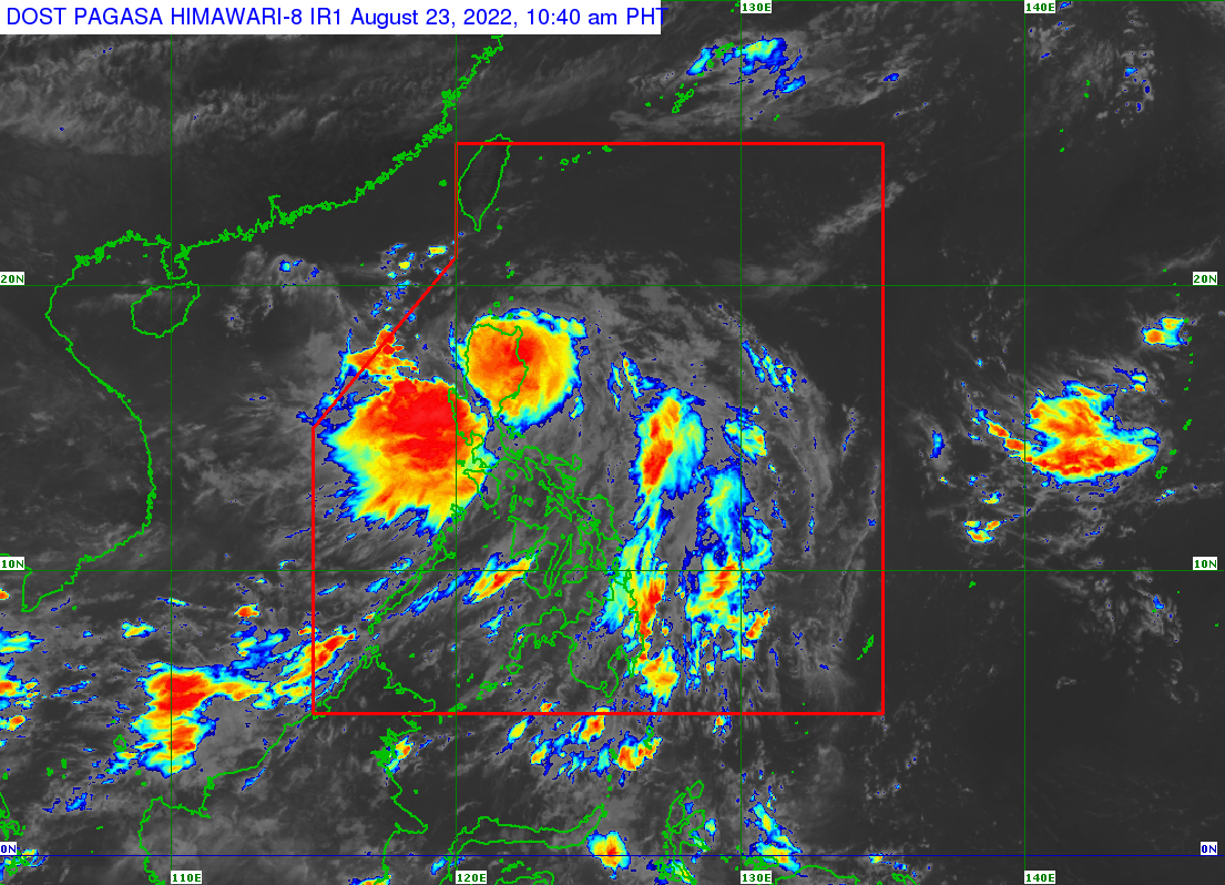
This image shows severe tropical storm Florita at 10:40 a.m., Tuesday. PAGASA
MANILA — Severe tropical storm Florita intensified further on Tuesday morning and made landfall in the northern province of Isabela, state weather bureau PAGASA said.
PAGASA said Florita hit land in Maconacon, Isabela at 10:30 a.m.
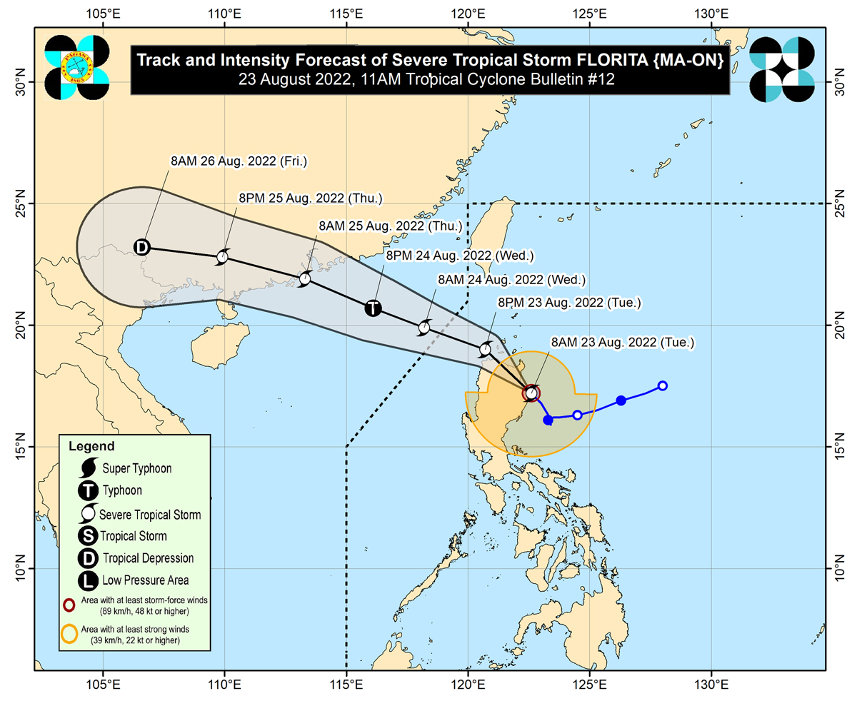
Florita was packing maximum sustained winds of 110 kilometers per hour near the center and up to 150 kph gusts, said the weather bureau.
PAGASA said heavy to intense with at times torrential rains will lash Cagayan, Isabela, Cordillera Administrative Region, Ilocos Region, Zambales, and Bataan.
ADVERTISEMENT
Moderate to heavy with at times intense rains are expected over the northern portion of Aurora, Tarlac, Pampanga, Bulacan, Metro Manila, Cavite, Rizal, and the rest of Cagayan Valley. Meanwhile, light to moderate with at times heavy rains will hit the rest of Central Luzon and the rest of Calabarzon.
PAGASA at 11 a.m. raised Tropical Cyclone Wind Signal no. 3 over the following areas, where 121 to 170 kph winds may cause heavy damage to high-risk structures.
Northern portion of Ilocos Norte (Pagudpud, Dumalneg, Adams, Bangui, Burgos), Apayao, the southern portion of Babuyan Islands (Camiguin Is., Fuga Is., Dalupiri Is.)
Mainland Cagayan
Northeastern portion of Isabela (Palanan, Divilacan, Maconacon, San Pablo, Tumauini, Cabagan, Santa Maria, Santo Tomas, Delfin Albano, Ilagan City, San Mariano)
Signal 2 is hoisted over the following areas, where 61 to 120 kph winds are expected in at least 24 hours, PAGASA said.
Rest of Babuyan Islands
Rest of Isabela
Quirino
Northern and eastern portion of Nueva Vizcaya (Quezon, Diadi, Bagabag, Villaverde, Solano, Kasibu)
Abra, Kalinga, Mountain Province, Ifugao
Northern portion of Benguet (Buguias, Bakun, Mankayan, Kibungan)
Rest of Ilocos Norte
Ilocos Sur
Northern portion of Aurora (Dilasag, Casiguran, Dinalungan, Dipaculao)
The following areas are under Signal 1, PAGASA added.
Batanes
Rest of Nueva Vizcaya
Rest of Benguet
La Union
Eastern portion of Pangasinan (Santo Tomas, Villasis, Mapandan, Mangaldan, San Fabian, San Jacinto, Manaoag, City of Urdaneta, Rosales, Balungao, Umingan, San Quintin, Natividad, San Nicolas, Tayug, Santa Maria, Asingan, San Manuel, Binalonan, Sison, Pozorrubio, Laoac, Dagupan City)
Northeastern portion of Tarlac (San Manuel, Anao)
Nueva Ecija
Rest of Aurora
Florita will continue moving northwestward and is forecast to cross the northern portion of Isabela and mainland Cagayan. It will emerge over the Babuyan Channel on Tuesday night and may exit the Philippine Area of Responsibility (PAR) on Wednesday morning, PAGASA said.
ABS-CBN is the leading media and entertainment company in the Philippines, offering quality content across TV, radio, digital, and film. Committed to public service and promoting Filipino values, ABS-CBN continues to inspire and connect audiences worldwide.
Our website is made possible by displaying online
advertisements to our visitors. Please consider supporting
us by disabling your ad blocker on our website.
Our website is made possible by displaying online
advertisements to our visitors. Please consider supporting
us by disabling your ad blocker on our website.