Egay nears super typhoon status; storm surge risk high in Batanes, Ilocos Norte | ABS-CBN


Welcome, Kapamilya! We use cookies to improve your browsing experience. Continuing to use this site means you agree to our use of cookies. Tell me more!
Egay nears super typhoon status; storm surge risk high in Batanes, Ilocos Norte
Egay nears super typhoon status; storm surge risk high in Batanes, Ilocos Norte
ABS-CBN News
Published Jul 25, 2023 06:58 AM PHT
|
Updated Jul 25, 2023 09:45 AM PHT
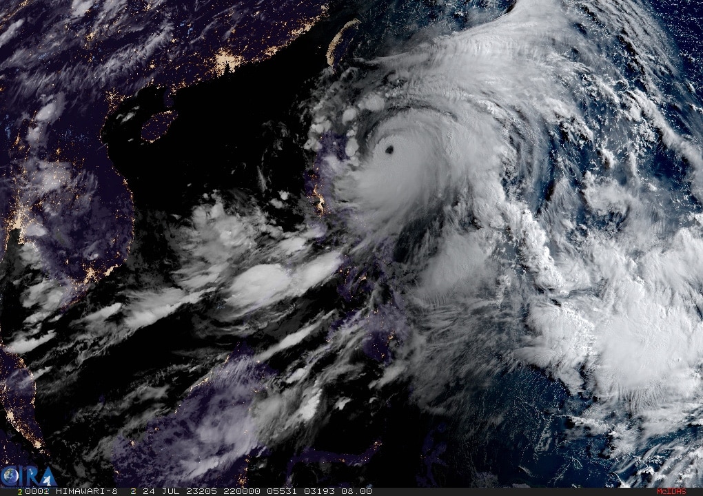
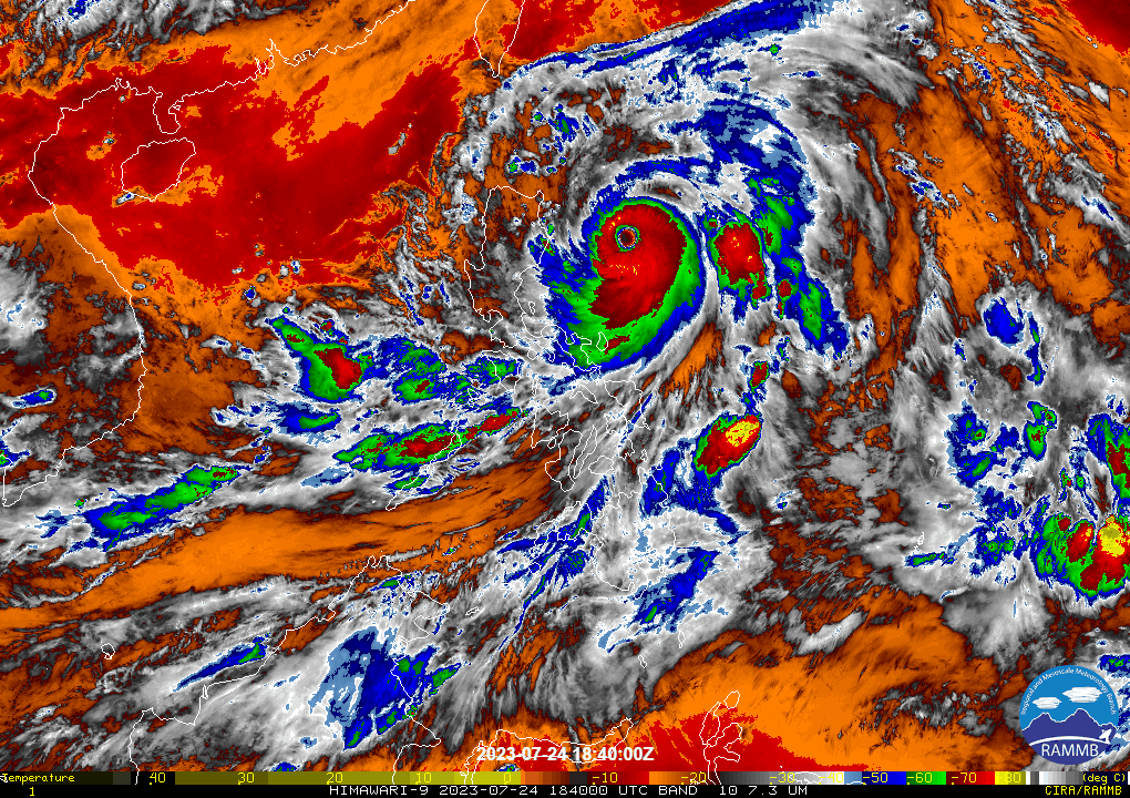
Typhoon Egay continues to gain strength and is forecast to become a super typhoon in the next 12 hours although the window of intensification is closing, weather bureau PAGASA said early Tuesday.
Typhoon Egay continues to gain strength and is forecast to become a super typhoon in the next 12 hours although the window of intensification is closing, weather bureau PAGASA said early Tuesday.
As of 4 a.m., the center of the typhoon was estimated at t 350 km east of Tuguegarao City, Cagayan. Packing 175 kps winds and 215 kph gusts, Egay is forecast to move northwestward in the next 12 hours before turning generally west northwestward and cross the Luzon Strait.
As of 4 a.m., the center of the typhoon was estimated at t 350 km east of Tuguegarao City, Cagayan. Packing 175 kps winds and 215 kph gusts, Egay is forecast to move northwestward in the next 12 hours before turning generally west northwestward and cross the Luzon Strait.
PAGASA said the typhoon is generating strong to typhoon-force winds extending outwards up to 680 km from the center.
PAGASA said the typhoon is generating strong to typhoon-force winds extending outwards up to 680 km from the center.
"Current forecast scenario shows that the highest wind signal that may be hoisted will be Wind Signal No. 4 or 5 (typhoon-force wind threat)," the bureau said.
"Current forecast scenario shows that the highest wind signal that may be hoisted will be Wind Signal No. 4 or 5 (typhoon-force wind threat)," the bureau said.
ADVERTISEMENT
On the track forecast, the typhoon is forecast to make landfall or pass very close to Babuyan Islands-northeastern mainland Cagayan area between late evening Tuesday and Wednesday afternoon.
On the track forecast, the typhoon is forecast to make landfall or pass very close to Babuyan Islands-northeastern mainland Cagayan area between late evening Tuesday and Wednesday afternoon.
"Slight northward or southward shift in this segment of the track (but within the forecast confidence cone) may result in a landfall or close approach over northern mainland Cagayan or Batanes," the weather bureau said.
"Slight northward or southward shift in this segment of the track (but within the forecast confidence cone) may result in a landfall or close approach over northern mainland Cagayan or Batanes," the weather bureau said.
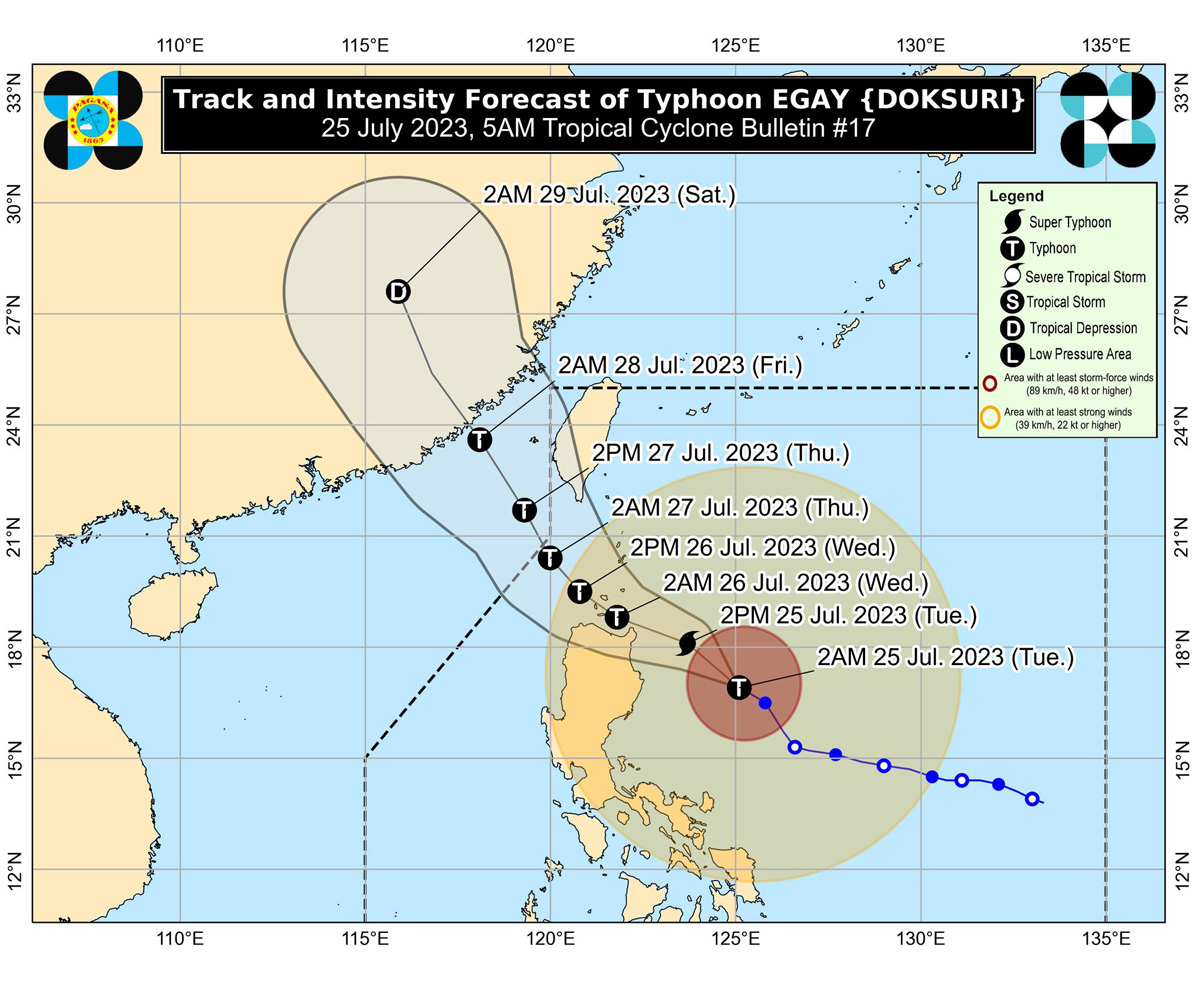
A weakening trend may begin as the typhoon passes over the Babuyan Islands due to the potential onset of eyewall replacement cycle and interaction with the rugged terrain of Northern Luzon.
A weakening trend may begin as the typhoon passes over the Babuyan Islands due to the potential onset of eyewall replacement cycle and interaction with the rugged terrain of Northern Luzon.
After passing the Babuyan Islands, Egay will turn northwestward or north northwestward and pass over the waters south of Taiwan. It is forecast to exit the Philippine Area of Responsibility on Thursday morning.
After passing the Babuyan Islands, Egay will turn northwestward or north northwestward and pass over the waters south of Taiwan. It is forecast to exit the Philippine Area of Responsibility on Thursday morning.
Outside the PAR region, EGAY will cross the Taiwan Strait and make landfall in the vicinity of Fujian, China on Friday morning.
Outside the PAR region, EGAY will cross the Taiwan Strait and make landfall in the vicinity of Fujian, China on Friday morning.
Tropical cyclone wind signal no. 3, signifying storm-force winds of 89 to 117 km/h, is up in the following areas:
Tropical cyclone wind signal no. 3, signifying storm-force winds of 89 to 117 km/h, is up in the following areas:
LUZON:
Babuyan Islands, the northern and eastern portions of mainland Cagayan (Santa Ana, Gonzaga, Peñablanca, Gattaran, Lal-Lo, Alcala, Santa Teresita, Buguey, Aparri, Camalaniugan, Ballesteros, Allacapan, Abulug, Claveria, Pamplona, Sanchez-Mira, Santa Praxedes, Lasam, Baggao, Amulung, Iguig), the northeastern portion of Isabela (Divilacan, Maconacon, Palanan), and the northern portion of Apayao (Calanasan, Luna, Santa Marcela, Flora, Pudtol)
Tropical cyclone wind signal no. 2, with gale-force winds of up 88 kph, is up in the following areas:
Tropical cyclone wind signal no. 2, with gale-force winds of up 88 kph, is up in the following areas:
LUZON:
Batanes, the rest of mainland Cagayan, the rest of Isabela, Quirino, the northern portion of Nueva Vizcaya (Kasibu, Quezon, Diadi, Bagabag, Ambaguio, Villaverde, Solano, Bayombong), the rest of Apayao, Kalinga, Abra, Mountain Province, Ifugao, the northern portion of Benguet (Bakun, Mankayan, Buguias, Kabayan, Kibungan), Ilocos Norte, Ilocos Sur, and the northern and central portion of Aurora (Dilasag, Casiguran, Dinalungan, Dipaculao)
Tropical cyclone wind signal no. 1 is up in the ff areas:
Tropical cyclone wind signal no. 1 is up in the ff areas:
LUZON:
La Union, Pangasinan, the rest of Benguet, the rest of Nueva Vizcaya, the rest of Aurora, Zambales, Bataan, Nueva Ecija, Tarlac, Pampanga, Bulacan, Metro Manila, Rizal, Laguna, Cavite, Batangas, Quezon, Marinduque, Camarines Norte, Camarines Sur, Catanduanes, Albay, Sorsogon, and the northern portion of Masbate (Uson, Dimasalang, City of Masbate, Mobo, Palanas, Aroroy, Baleno) including Burias and Ticao Islands
VISAYAS:
Northern Samar, the northern portion of Samar (San Jose de Buan, Matuguinao, Gandara, Santa Margarita, Calbayog City), and the northern portion of Eastern Samar (Oras, Arteche, Jipapad, Dolores, San Policarpo, Maslog)
VISAYAS:
Northern Samar, the northern portion of Samar (San Jose de Buan, Matuguinao, Gandara, Santa Margarita, Calbayog City), and the northern portion of Eastern Samar (Oras, Arteche, Jipapad, Dolores, San Policarpo, Maslog)
The weather bureau warned there is a high risk of storm surge "which may cause flooding in the low-lying and exposed coastal areas of Batanes, Cagayan including Babuyan Islands, Isabela, and Ilocos Norte."
The weather bureau warned there is a high risk of storm surge "which may cause flooding in the low-lying and exposed coastal areas of Batanes, Cagayan including Babuyan Islands, Isabela, and Ilocos Norte."
"Maximum surge heights may exceed 3.0 m is some of the warning areas," it said.
"Maximum surge heights may exceed 3.0 m is some of the warning areas," it said.
PAGASA also warned of above 200 mm accumulated rainfall Tuesday in the eastern portion of Babuyan Islands and the northern portions of mainland Cagayan, Apayao, and Ilocos Norte.
PAGASA also warned of above 200 mm accumulated rainfall Tuesday in the eastern portion of Babuyan Islands and the northern portions of mainland Cagayan, Apayao, and Ilocos Norte.
The bureau also warned of 100-200 mm accumulated rainfall in Ilocos Sur, Abra, the northern portion of La Union, the western portion of Kalinga, and the rest of Babuyan Islands, mainland Cagayan, and Apayao, and 50-100 mm accumulated rainfall in Batanes, the northern and eastern portions of Isabela, the northern portion of Zambales, and the rest of Ilocos Region and Cordillera Administrative Region.
The bureau also warned of 100-200 mm accumulated rainfall in Ilocos Sur, Abra, the northern portion of La Union, the western portion of Kalinga, and the rest of Babuyan Islands, mainland Cagayan, and Apayao, and 50-100 mm accumulated rainfall in Batanes, the northern and eastern portions of Isabela, the northern portion of Zambales, and the rest of Ilocos Region and Cordillera Administrative Region.
"Forecast rainfall are generally higher in elevated or mountainous areas. Under these conditions, flooding and rain-induced landslides are highly likely especially in areas that are highly or very highly susceptible to these hazards as identified in hazard maps and in localities that experienced considerable amounts of rainfall for the past several days," it said.
"Forecast rainfall are generally higher in elevated or mountainous areas. Under these conditions, flooding and rain-induced landslides are highly likely especially in areas that are highly or very highly susceptible to these hazards as identified in hazard maps and in localities that experienced considerable amounts of rainfall for the past several days," it said.
The Southwest Monsoon enhanced by EGAY will continue to bring occasional to monsoon rains over the western portions of Central Luzon, Southern Luzon, and Visayas in the next three days.
The Southwest Monsoon enhanced by EGAY will continue to bring occasional to monsoon rains over the western portions of Central Luzon, Southern Luzon, and Visayas in the next three days.
ADVERTISEMENT
ADVERTISEMENT