Josie gains speed, threatens Babuyan Islands: PAGASA | ABS-CBN


Welcome, Kapamilya! We use cookies to improve your browsing experience. Continuing to use this site means you agree to our use of cookies. Tell me more!
Josie gains speed, threatens Babuyan Islands: PAGASA
Josie gains speed, threatens Babuyan Islands: PAGASA
ABS-CBN News
Published Jul 21, 2018 08:55 PM PHT
|
Updated Jul 21, 2018 11:49 PM PHT
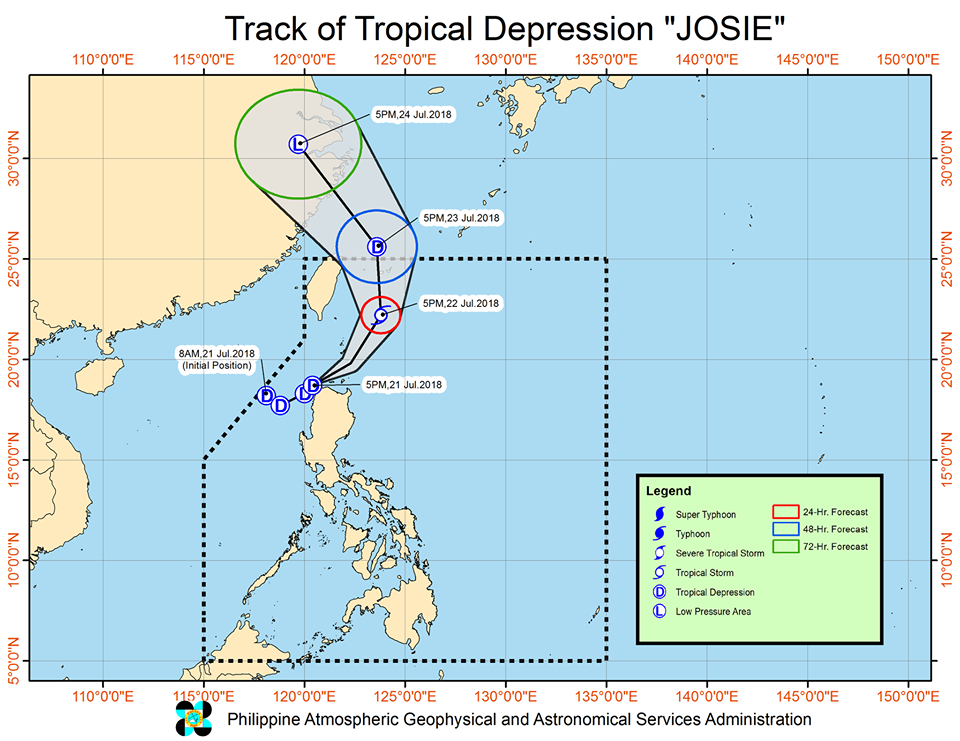
MANILA—Tropical Depression Josie has gained speed as it threatens the Babuyan group of islands, state weather bureau PAGASA said Saturday night.
MANILA—Tropical Depression Josie has gained speed as it threatens the Babuyan group of islands, state weather bureau PAGASA said Saturday night.
In its latest weather bulletin, PAGASA said Josie is already heading towards the Babuyan Group of Islands after nearing the Negra and Mayraira points in Ilocos Norte.
In its latest weather bulletin, PAGASA said Josie is already heading towards the Babuyan Group of Islands after nearing the Negra and Mayraira points in Ilocos Norte.
Tropical cyclone warning signal no. 1 remains hoisted over the following areas:
- Batanes
- Northern Cagayan including the Babuyan Group of Islands
- Ilocos Norte
- Apayao
- northern parts of Abra
Tropical cyclone warning signal no. 1 remains hoisted over the following areas:
- Batanes
- Northern Cagayan including the Babuyan Group of Islands
- Ilocos Norte
- Apayao
- northern parts of Abra
Josie is now moving faster at 35 kph from its earlier speed of 25 kph, PAGASA said.
Josie is now moving faster at 35 kph from its earlier speed of 25 kph, PAGASA said.
ADVERTISEMENT
It was last spotted at 70 km north of Laoag City, Ilocos Norte as of 7 p.m. and is moving east, northeast. The storm packs maximum winds of up to 55 kph near the center and gusts of up to 75 kph.
It was last spotted at 70 km north of Laoag City, Ilocos Norte as of 7 p.m. and is moving east, northeast. The storm packs maximum winds of up to 55 kph near the center and gusts of up to 75 kph.
Because of the weather disturbance, PAGASA said scattered to widespread moderate and heavy rains will prevail over Ilocos Region, Cordillera Administrative Region, Batanes, Babuyan Group of Islands, Zambales, Tarlac, and Nueva Ecija.
Because of the weather disturbance, PAGASA said scattered to widespread moderate and heavy rains will prevail over Ilocos Region, Cordillera Administrative Region, Batanes, Babuyan Group of Islands, Zambales, Tarlac, and Nueva Ecija.
Scattered light to moderate with occasional heavy rains meanwhile are expected over Metro Manila, CALABARZON, the rest of Central Luzon and of Cagayan Valley, and Mindoro provinces.
Scattered light to moderate with occasional heavy rains meanwhile are expected over Metro Manila, CALABARZON, the rest of Central Luzon and of Cagayan Valley, and Mindoro provinces.
Residents of said areas are advised to take appropriate actions against possible flooding and landslide.
Residents of said areas are advised to take appropriate actions against possible flooding and landslide.
Sea travel also remains risky over the seaboards of Northern Luzon and the western seaboard of Central Luzon, especially in areas under tropical cyclone warning signal no.1.
Sea travel also remains risky over the seaboards of Northern Luzon and the western seaboard of Central Luzon, especially in areas under tropical cyclone warning signal no.1.
Josie, the fourth storm to hit the country this month, is expected to leave the Philippine area of responsibility on Tuesday afternoon.
Josie, the fourth storm to hit the country this month, is expected to leave the Philippine area of responsibility on Tuesday afternoon.
Visit the ABS-CBN Weather Center for the latest weather updates.
ADVERTISEMENT
ADVERTISEMENT