Welcome, Kapamilya! We use cookies to improve your browsing experience. Continuing to use this site means you agree to our use of cookies. Tell me more!
Betty may trigger floods, landslides; wind signals up in several areas
Betty may trigger floods, landslides; wind signals up in several areas
Raffy Cabristante,
ABS-CBN News
Published May 29, 2023 12:47 PM PHT
|
Updated May 29, 2023 06:57 PM PHT
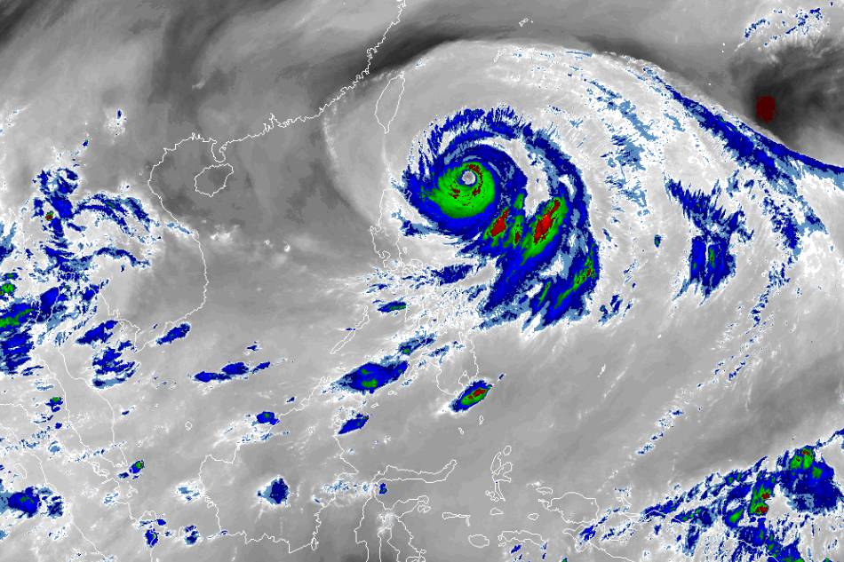
RAMMB/US NOAA/Himawari 8
MANILA (2nd UPDATE) — Rains from typhoon Betty may unleash floods and landslides in some parts of Luzon, state weather bureau PAGASA said on Monday, as it raised warning signals for strong winds over a dozen areas.
Betty (international name Mawar) continued to slow down while moving north-northwestward over the waters east of Cagayan, PAGASA said in its 5 p.m. bulletin.
It cautioned residents in parts of northern Luzon to brace for heavy rains between 50 and 200 millimeters until Tuesday, including Batanes, Babuyan Islands, the northern portion of mainland Cagayan, Ilocos Norte, Ilocos Sur, La Union, Abra, and Benguet.
Rains will continue in the said areas until Friday, the agency added.
ADVERTISEMENT
"Mula ngayon hanggang mamaya, makakaranas pa sila ng mga bugso ng hangin," PAGASA officer-in-charge Esperanza Cayanan said in a public briefing Monday.
(From now until later, they will also experience gusts.)
PAGASA raised tropical cyclone wind signals in the following areas.
SIGNAL NO. 2
- Batanes
- Northeastern portion of Cagayan (Santa Ana, Gonzaga)
- Babuyan Islands
Strong winds may damage houses made of light materials in these areas, PAGASA Assistant Weather Services Chief Chris Perez said in a press briefing.
SIGNAL NO. 1
- The rest of mainland Cagayan
- Isabela
- Apayao
- Ilocos Norte
- Abra
- Kalinga
- Mountain Province
- Ifugao
- Northern and central portions of Aurora (Dilasag, Casiguran, Dinalungan, Dipaculao, Baler)
- Quirino
- Northeastern portion of Nueva Vizcaya (Kasibu, Quezon, Solano, Bagabag, Diadi, Villaverde, Bayombong, Ambaguio)
- Northeastern portion of Camarines Sur (Caramoan, Garchitorena, Lagonoy, Tinambac, Siruma)
- Pollilo Islands
- Northern portion of Camarines Norte (Vinzons, Paracale, Jose Panganiban, Capalonga, Talisay, Daet, Mercedes, Basud)
- Northern and central portions of Ilocos Sur (Gregorio del Pilar, Magsingal, San Esteban, Banayoyo, Cervantes, Burgos, Santiago, San Vicente, Santa Catalina, Lidlidda, Nagbukel, Sinait, Sigay, San Ildefonso, Galimuyod, Quirino, City of Vigan, San Emilio, Cabugao, Caoayan, San Juan, Santa, Bantay, Santo Domingo, Santa Maria, Narvacan, Salcedo, City of Candon)
"Baka nagtataka kayo, warning signal number 1 na tayo, pero wala pang ulan, may araw pa po. ‘Pag nagtataas tayo ng warning signal, karaniwan po may panahon pa tayo para mag-prepare, may tinatawag tayong lead time," PAGASA's Perez said.
ADVERTISEMENT
"Hindi naman po tayo magbibigay ng warning kung and’yan na yung ulan, and’yan na yung malakas na hangin. Sa ngayon pa lang po, yung lugar na may warning signal, binibigyan na po natin ng paunang abiso na kailangan maging handa at patuloy ngang makipag-ugnayan sa kanilang local government," he added.
(You may be wondering why we're under signal 1 and yet there are no rains yet, the sun is still out. When we raise warning signals, we usually still have time to prepare, we have so-called lead time. We won't issue a warning when the rains and strong winds are already there. As early as now, areas with warning signals need to prepare and coordinate with their local government.)
As Betty is also starting to enhance the southwest monsoon (habagat), occasional gusts may be experienced over localities in the eastern portion of central Luzon, eastern and southern portions of southern Luzon, and most of Visayas, PAGASA added.
Southern Luzon and western Visayas will also be experiencing monsoon rains, including Occidental Mindoro, Antique, the northwestern portion of Aklan, the western portion of Romblon, and Calamian Islands.
"Under these conditions, flooding and rain-induced landslides are possible, especially in areas that are highly or very highly susceptible to these hazard as identified in hazard maps and in localities that experienced considerable amounts of rainfall for the past several days," PAGASA warned.
ADVERTISEMENT
PAGASA officer-in-charge Dr. Esperanza Cayanan also said the western section of central Luzon and Metro Manila will also experience moderate rains brought by the enhanced southwest monsoon.
"Makararanas din ang western section ng central Luzon and Metro Manila could experience also mga pag-ulan, pero hindi naman po sobrang lakas ng ulan na inaasahan natin [sa] Tuesday, Wednesday," she said.
At 5 p.m., Betty was spotted 445 kilometers east of Calayan, Cagayan, packing maximum winds of 155 kilometers per hour and 190 kph gusts, PAGASA said.
Due to cooler ocean waters, Betty may weaken into a severe tropical storm by late Thursday or early Friday, and later into a tropical storm by late Friday or early Saturday as it continues to move toward Taiwan.
Betty is expected to leave the Philippine area of responsibility (PAR) by Friday, PAGASA said.
ABS-CBN is the leading media and entertainment company in the Philippines, offering quality content across TV, radio, digital, and film. Committed to public service and promoting Filipino values, ABS-CBN continues to inspire and connect audiences worldwide.
Our website is made possible by displaying online
advertisements to our visitors. Please consider supporting
us by disabling your ad blocker on our website.
Our website is made possible by displaying online
advertisements to our visitors. Please consider supporting
us by disabling your ad blocker on our website.