Super typhoon Mawar expected to further intensify | ABS-CBN

Welcome, Kapamilya! We use cookies to improve your browsing experience. Continuing to use this site means you agree to our use of cookies. Tell me more!
Super typhoon Mawar expected to further intensify
Super typhoon Mawar expected to further intensify
ABS-CBN News
Published May 26, 2023 12:31 AM PHT
|
Updated May 26, 2023 12:41 PM PHT
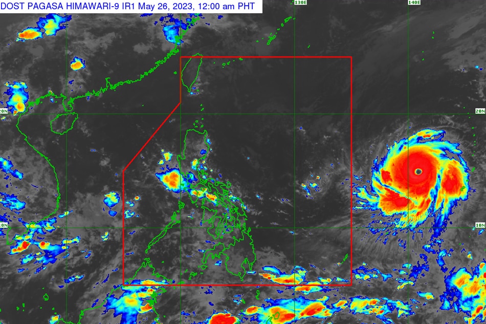
MANILA (UPDATE) — Super typhoon Mawar is expected further intensify and reach its peak strength in 24 to 36 hours, state weather bureau PAGASA said late Thursday evening.
MANILA (UPDATE) — Super typhoon Mawar is expected further intensify and reach its peak strength in 24 to 36 hours, state weather bureau PAGASA said late Thursday evening.
In an update early Friday morning, PAGASA said Mawar was located 1,740 km east of southeastern Luzon as of 3 a.m. , with maximum sustained winds of 215 kph near the center and gusts of up to 265 kph.
In an update early Friday morning, PAGASA said Mawar was located 1,740 km east of southeastern Luzon as of 3 a.m. , with maximum sustained winds of 215 kph near the center and gusts of up to 265 kph.
It is moving westward at 20 kph.
It is moving westward at 20 kph.
It is expected to accelerate as it continues to barrel towards the Philippine area of responsibility.
It is expected to accelerate as it continues to barrel towards the Philippine area of responsibility.
ADVERTISEMENT
The tropical cyclone will enter PAR by Friday evening or Saturday morning.
The tropical cyclone will enter PAR by Friday evening or Saturday morning.
The weather agency said Mawar may begin to slow down by Saturday.
The weather agency said Mawar may begin to slow down by Saturday.
"The super typhoon may slightly weaken by Saturday but is expected to remain as a super typhoon until Sunday or early Monday due to highly favorable environment. Mawar will then weaken at a slightly faster rate by Monday or Tuesday as unfavorable conditions (e.g., increasing wind shear, cooler sea surface temperature resulting from its slowdown by that time, dry air intrusion) take place," PAGASA said in its 11 p.m. advisory on Thursday.
"The super typhoon may slightly weaken by Saturday but is expected to remain as a super typhoon until Sunday or early Monday due to highly favorable environment. Mawar will then weaken at a slightly faster rate by Monday or Tuesday as unfavorable conditions (e.g., increasing wind shear, cooler sea surface temperature resulting from its slowdown by that time, dry air intrusion) take place," PAGASA said in its 11 p.m. advisory on Thursday.
The agency warned northern Luzon residents that the super typhoon might cause heavy rains and may trigger flooding or landslides in their areas beginning late Sunday or on Monday next week.
The agency warned northern Luzon residents that the super typhoon might cause heavy rains and may trigger flooding or landslides in their areas beginning late Sunday or on Monday next week.
"In addition, strong to storm-force conditions may be experienced over Extreme Northern Luzon, while strong to gale-force conditions are possible over the northern and eastern portions of Northern Luzon mainland. This will result in the hoisting of Wind Signals by tomorrow or on Saturday an anticipation of these severe winds," it said.
"In addition, strong to storm-force conditions may be experienced over Extreme Northern Luzon, while strong to gale-force conditions are possible over the northern and eastern portions of Northern Luzon mainland. This will result in the hoisting of Wind Signals by tomorrow or on Saturday an anticipation of these severe winds," it said.
Mawar is expected to enhance the southwest monsoon or habagat and bring rainy weather by early next week over broad swaths of the country.
Mawar is expected to enhance the southwest monsoon or habagat and bring rainy weather by early next week over broad swaths of the country.
For more updates, visit the ABS-CBN Weather Center.
For more updates, visit the ABS-CBN Weather Center.
Read More:
Mawar
super typhoon Mawar
PAGASA
Philippine weather updates
Philippine storm updates
bagyo
Mawar update
ADVERTISEMENT
ADVERTISEMENT


