Welcome, Kapamilya! We use cookies to improve your browsing experience. Continuing to use this site means you agree to our use of cookies. Tell me more!
FACT CHECK: No, this is not a photo of a recent PH earthquake
FACT CHECK: No, this is not a photo of a recent PH earthquake
Agence France-Presse
Published Apr 26, 2019 05:26 PM PHT
A picture of a damaged road has been shared hundreds of times in a Facebook post which announces ‘breaking’ news of an earthquake that hit the Philippines this week. The image actually shows destruction from a separate 2012 quake in a different region of the country.
The photo, contained in this Facebook post which has been shared around 1,400 times since it was published April 23, 2019, shows people carrying their belongings along a road which has collapsed.
The post’s caption says: “BREAKING: A magnitude 6.2 earthquake struck Eastern Samar at 1:37PM MNL time.”
Below is a screenshot of the post:
ADVERTISEMENT
Screenshot of Facebook post
An earthquake did hit the central Philippine island of Samar on April 23 at 1:37 pm local time.
The US Geological Survey put the magnitude at 6.4 on its website, while Philippine seismologists reported it was a 6.5 strength quake.
That tremor struck a day after a 6.3-magnitude earthquake hit northwest of the capital Manila.
However, a reverse image search using verification tool Tineye traced the photo in the post back to the website of international news agency Reuters.
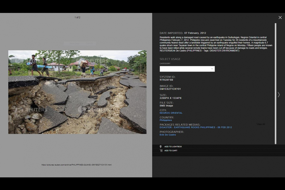
The photo’s caption says it is from February 7, 2012, and shows a road damaged by an earthquake in Guihulngan, Negros Oriental in the central Philippines – around 250 kilometres (150 miles) from Eastern Samar.
Below is a screenshot of the Reuters photo:
Screenshot of image
The Reuters photo can also be seen in this February 8, 2012 article published by the International Business Times. It is the sixth image in the photo gallery.
ABS-CBN is the leading media and entertainment company in the Philippines, offering quality content across TV, radio, digital, and film. Committed to public service and promoting Filipino values, ABS-CBN continues to inspire and connect audiences worldwide.
Our website is made possible by displaying online
advertisements to our visitors. Please consider supporting
us by disabling your ad blocker on our website.
Our website is made possible by displaying online
advertisements to our visitors. Please consider supporting
us by disabling your ad blocker on our website.