More areas in Luzon under Signal No. 1 as Amang nears Bicol | ABS-CBN


Welcome, Kapamilya! We use cookies to improve your browsing experience. Continuing to use this site means you agree to our use of cookies. Tell me more!
More areas in Luzon under Signal No. 1 as Amang nears Bicol
More areas in Luzon under Signal No. 1 as Amang nears Bicol
ABS-CBN News
Published Apr 11, 2023 12:07 PM PHT
|
Updated Apr 11, 2023 06:11 PM PHT
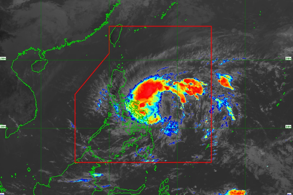
MANILA — More areas in Luzon have been placed under Tropical Cyclone Wind Signal No. 1 as Tropical Depression Amang moved nearer to the Philippine landmass, PAGASA said Tuesday.
MANILA — More areas in Luzon have been placed under Tropical Cyclone Wind Signal No. 1 as Tropical Depression Amang moved nearer to the Philippine landmass, PAGASA said Tuesday.
In its latest bulletin issued 11 a.m., PAGASA said Amang had accelerated as it moved westward towards the coast of Catanduanes province.
In its latest bulletin issued 11 a.m., PAGASA said Amang had accelerated as it moved westward towards the coast of Catanduanes province.
The state weather bureau raised Signal No. 1 over some provinces in Bicol, Calabarzon, Mimaropa, and Eastern Visayas due to the threat of the cyclone:
The state weather bureau raised Signal No. 1 over some provinces in Bicol, Calabarzon, Mimaropa, and Eastern Visayas due to the threat of the cyclone:
- Catanduanes
- Sorsogon
- Albay
- Camarines Sur
- Camarines Norte
- Quezon (Pitogo, San Andres, Buenavista, San Francisco, Calauag, Infanta, Lopez, Catanauan, Mulanay, Guinayangan, Unisan, General Luna, Plaridel, Quezon, Alabat, Sampaloc, Padre Burgos, Macalelon, Mauban, General Nakar, Perez, Agdangan, Gumaca, Atimonan, Real, San Narciso, Tagkawayan, Pagbilao, City of Tayabas) including Pollilo Islands
- Marinduque
- Masbate including Ticao Island
- Burias Island
- Eastern Samar
- Northern Samar
- Samar
- Biliran
Other localities in Eastern Visayas and Bicol Region may also be placed under Signal No. 1 in the next few hours.
Other localities in Eastern Visayas and Bicol Region may also be placed under Signal No. 1 in the next few hours.
ADVERTISEMENT
Areas under Signal No. 1 are expected to experience strong winds 36 hours, the state weather bureau said. Heavy to intense rains are also expected in the said areas.
Areas under Signal No. 1 are expected to experience strong winds 36 hours, the state weather bureau said. Heavy to intense rains are also expected in the said areas.
"Under these conditions, flooding and rain-induced landslides are possible, especially in areas that are highly or very highly susceptible to these hazard as identified in hazard maps and in localities that experienced considerable amounts of rainfall for the past several days," PAGASA also said.
"Under these conditions, flooding and rain-induced landslides are possible, especially in areas that are highly or very highly susceptible to these hazard as identified in hazard maps and in localities that experienced considerable amounts of rainfall for the past several days," PAGASA also said.
The center of Tropical Depression Amang was last estimated about 270 kilometers east of Virac, Catanduanes, packing maximum sustained winds of 55 kph near the center and gustiness of up to 70 kph.
The center of Tropical Depression Amang was last estimated about 270 kilometers east of Virac, Catanduanes, packing maximum sustained winds of 55 kph near the center and gustiness of up to 70 kph.
It was moving westward at 30 kph.
It was moving westward at 30 kph.
Based on PAGASA's latest forecast track, Amang is seen to move generally westward or west northwestward towards Bicol Region.
Based on PAGASA's latest forecast track, Amang is seen to move generally westward or west northwestward towards Bicol Region.
"While the current track forecast shows that the tropical depression will remain offshore over the waters east of Luzon for the next 3 days, the forecast confidence cone shows that a landfall scenario over the Bicol Peninsula area is not ruled out, especially for the next 36 hours," PAGASA said.
"While the current track forecast shows that the tropical depression will remain offshore over the waters east of Luzon for the next 3 days, the forecast confidence cone shows that a landfall scenario over the Bicol Peninsula area is not ruled out, especially for the next 36 hours," PAGASA said.
But the state weather bureau also forecasted that Amang will remain as a tropical depression, and may weaken into a low-pressure area (LPA) by late Thursday or Early Friday.
But the state weather bureau also forecasted that Amang will remain as a tropical depression, and may weaken into a low-pressure area (LPA) by late Thursday or Early Friday.
RELATED VIDEO:
ADVERTISEMENT
ADVERTISEMENT