Welcome, Kapamilya! We use cookies to improve your browsing experience. Continuing to use this site means you agree to our use of cookies. Tell me more!
Luzon, Visayas areas under signal no. 1 as Amang keeps strength
Luzon, Visayas areas under signal no. 1 as Amang keeps strength
ABS-CBN News
Published Apr 11, 2023 06:10 PM PHT
|
Updated Apr 12, 2023 06:51 AM PHT
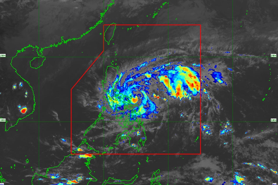
Tropical depression Amang as of 5 p.m. Tuesday. PAGASA photo
MANILA — Broad swaths of Luzon and Visayas were placed under Tropical Cyclone Wind Signal No. 1 as tropical depression Amang maintained its strength and continued to move westward toward the northern coast of Catanduanes, the state weather bureau said Tuesday.
Amang was 130 kilometers east-northeast of Virac, Catanduanes at 4 p.m. Tuesday, PAGASA said, packing maximum sustained winds of 55 kilometers per hour near the center and gusts of up to 70 kph. It is moving westward at 30 kph.
PAGASA raised signal no. 1 in the following areas, where 39 to 61 kph winds could be expected in 36 hours.
LUZON
Catanduanes
Sorsogon
Albay
Camarines Sur
Camarines Norte
Quezon including Polillo Islands
Marinduque
Masbate including Ticao Island, Burias Island
Rizal
Laguna (San Pablo City, Alaminos, Calauan, Bay, Los Baños, Rizal, Nagcarlan, Victoria, Pila, Liliw, Magdalena, Majayjay, Luisiana, Cavinti, Pagsanjan, Santa Cruz, Lumban, Kalayaan, Paete, Pakil, Pangil, Siniloan, Famy, Santa Maria, Mabitac)
Aurora
Bulacan (Norzagaray, Doña Remedios Trinidad, San Miguel, San Ildefonso), Quirino, Nueva Vizcaya (Kasibu, Dupax del Norte, Dupax del Sur, Alfonso Castaneda)
Nueva Ecija (General Tinio, City of Gapan, Peñaranda, San Leonardo, Santa Rosa, Cabanatuan City, Talavera, San Jose City, Carranglan, Pantabangan, Llanera, General Mamerto Natividad, Rizal, Bongabon, Laur, Palayan City, Gabaldon)
Isabela (Echague, San Agustin, Jones, Dinapigue, San Mariano, San Guillermo, Palanan, Angadanan, Benito Soliven, City of Cauayan)
VISAYAS
Northern Samar
Samar (Calbayog City, Matuguinao, San Jose de Buan, Gandara, Santa Margarita, San Jorge) and Eastern Samar (Jipapad, Maslog, Arteche, Oras, San Policarpo, Dolores)
The areas placed under signal no. 1 could experience strong winds brought about by the storm. PAGASA said the threat to life and property is "minimal to minor."
ADVERTISEMENT
RAINFALL
According to PAGASA's 5 p.m. bulletin, downpours could dump up to 100 mm of rain over the Bicol region and Northern Samar, while intense rains of up to 200 mm could be expected in the northern portion of Quezon and the eastern portion of Laguna.
Meanwhile, rain showers could unleash up to 100 mm of rain over Rizal province, the southern portion of Aurora, and the rest of Laguna and Quezon, it added.
The weather agency warned that flooding and landslides are possible.
OUTLOOK
PAGASA said that although Amang is predicted to remain over the coastal waters, it is not ruling out a landfall scenario in the Bicol Peninsula area, adding it "may pass over or very close near Catanduanes" in the next 9 hours.
Amang's track will follow a generally westward or west-northwestward track towards Bicol Region Tuesday. It will then turn west-northwestward or northwestward for the remainder of the forecast period.
The weather agency added that Amang, the nation's first storm this year, is forecast to remain a tropical depression and it might be downgraded to a low-pressure area "by late Thursday or early Friday."
"Wind Signal No. 1 may be hoisted in other localities in Central Luzon and Cagayan Valley in succeeding bulletins," it also said.
ABS-CBN is the leading media and entertainment company in the Philippines, offering quality content across TV, radio, digital, and film. Committed to public service and promoting Filipino values, ABS-CBN continues to inspire and connect audiences worldwide.
Our website is made possible by displaying online
advertisements to our visitors. Please consider supporting
us by disabling your ad blocker on our website.
Our website is made possible by displaying online
advertisements to our visitors. Please consider supporting
us by disabling your ad blocker on our website.