Agaton makes 2nd landfall over Samar; some areas under Signal No. 1 | ABS-CBN

Welcome, Kapamilya! We use cookies to improve your browsing experience. Continuing to use this site means you agree to our use of cookies. Tell me more!
News
Agaton makes 2nd landfall over Samar; some areas under Signal No. 1
Agaton makes 2nd landfall over Samar; some areas under Signal No. 1
ABS-CBN News
Published Apr 11, 2022 06:41 PM PHT
|
Updated Apr 11, 2022 09:36 PM PHT
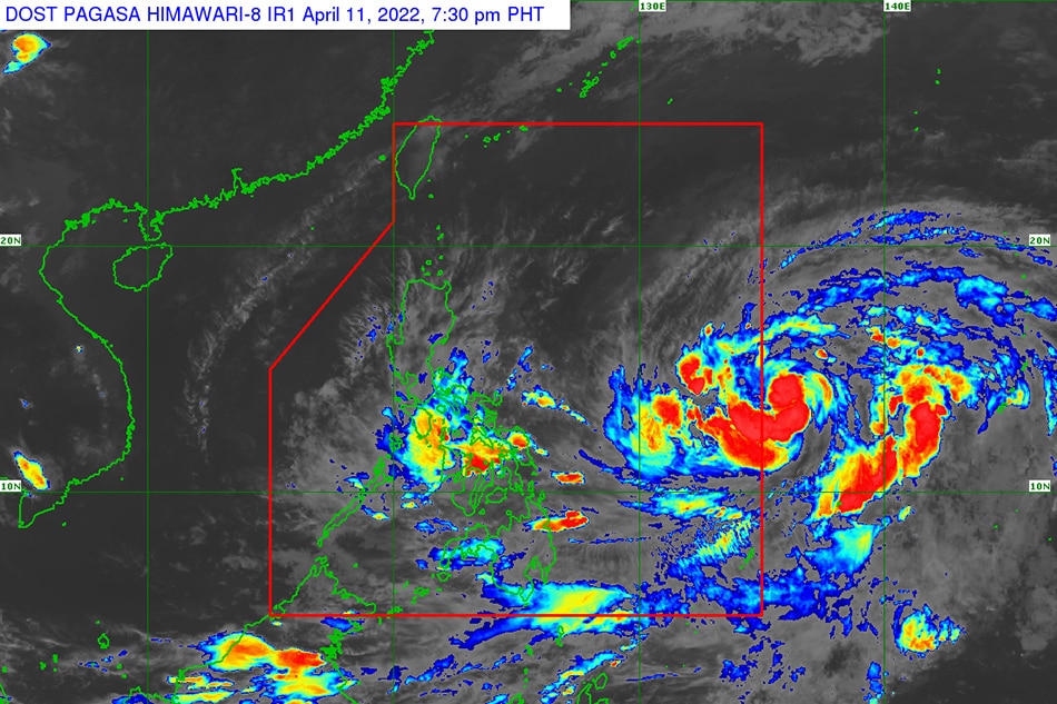
MANILA (UPDATED) — Tropical Depression Agaton (international name: Megi) made another landfall on Monday afternoon, this time over Basey, Samar, PAGASA said.
MANILA (UPDATED) — Tropical Depression Agaton (international name: Megi) made another landfall on Monday afternoon, this time over Basey, Samar, PAGASA said.
According to the state weather bureau, Agaton's second landfall was recorded at 4 p.m. It first hit land in Calicoan Island in Guiuan, Eastern Samar on Sunday morning.
According to the state weather bureau, Agaton's second landfall was recorded at 4 p.m. It first hit land in Calicoan Island in Guiuan, Eastern Samar on Sunday morning.
As of 7 p.m., Agaton was last located in the vicinity of Basey in Samar. It continues to pack winds of 45 kilometers per hour, with gusts of up to 60 kph, while moving northward slowly.
As of 7 p.m., Agaton was last located in the vicinity of Basey in Samar. It continues to pack winds of 45 kilometers per hour, with gusts of up to 60 kph, while moving northward slowly.
PAGASA said in its 8 p.m. bulletin that the following areas are under Signal No. 1:
PAGASA said in its 8 p.m. bulletin that the following areas are under Signal No. 1:
ADVERTISEMENT
LUZON
- Southern portion of Masbate: Dimasalang, Palanas, Cataingan, Pio V. Corpuz, Esperanza, Placer, and Cawayan
- Southern portion of Masbate: Dimasalang, Palanas, Cataingan, Pio V. Corpuz, Esperanza, Placer, and Cawayan
VISAYAS
- Eastern Samar
- Samar
- Northern Samar
- Biliran
- Leyte
- Southern Leyte
- Northeastern portion of Cebu, including Camotes Island: Daanbantayan, Medellin, City of Bogo, Tabogon, Borbon, Sogod
- Eastern Samar
- Samar
- Northern Samar
- Biliran
- Leyte
- Southern Leyte
- Northeastern portion of Cebu, including Camotes Island: Daanbantayan, Medellin, City of Bogo, Tabogon, Borbon, Sogod
MINDANAO
- Dinagat Islands and Bucas Grande Islands
- Dinagat Islands and Bucas Grande Islands
PAGASA cautioned residents in the said areas to prepare for strong winds.
PAGASA cautioned residents in the said areas to prepare for strong winds.
Some provinces in Luzon and the Visayas will continue to experience rains, the state weather bureau said.
Some provinces in Luzon and the Visayas will continue to experience rains, the state weather bureau said.
“Heavy rains will continue to batter Masbate, Sorsogon, Romblon, and most of Visayas. Widespread and serious flooding and landslides remain a threat,” PAGASA said.
“Heavy rains will continue to batter Masbate, Sorsogon, Romblon, and most of Visayas. Widespread and serious flooding and landslides remain a threat,” PAGASA said.
Moderate to heavy with at times intense rains may persist over Sorsogon, Masbate, Romblon, Biliran, Leyte, Southern Leyte, the northern and central portions of Cebu including Bantayan and Camotes Islands, Aklan, Capiz, Iloilo, Antique, Guimaras, and the northern and central portions of Negros Provinces.
Moderate to heavy with at times intense rains may persist over Sorsogon, Masbate, Romblon, Biliran, Leyte, Southern Leyte, the northern and central portions of Cebu including Bantayan and Camotes Islands, Aklan, Capiz, Iloilo, Antique, Guimaras, and the northern and central portions of Negros Provinces.
Light to moderate with at times heavy rains will be experienced over Dinagat Islands, Oriental Mindoro, Occidental Mindoro, Marinduque, Quezon, and the rest of Bicol Region and Visayas.
Light to moderate with at times heavy rains will be experienced over Dinagat Islands, Oriental Mindoro, Occidental Mindoro, Marinduque, Quezon, and the rest of Bicol Region and Visayas.
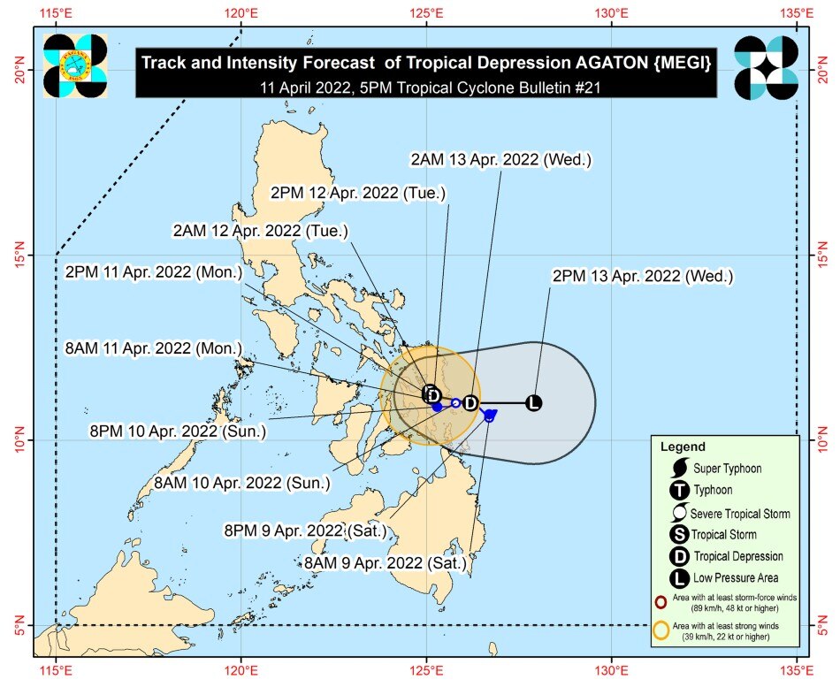
Based on PAGASA’s latest forecast track, Agaton will “slowly loop” in the vicinity of southern portions of Samar and Eastern Samar before emerging over the Philippine Sea by Tuesday evening.
Based on PAGASA’s latest forecast track, Agaton will “slowly loop” in the vicinity of southern portions of Samar and Eastern Samar before emerging over the Philippine Sea by Tuesday evening.
By then, it will begin to interact with Severe Tropical Storm “Malakas,” and is expected to weaken into a remnant low pressure area by Wednesday.
By then, it will begin to interact with Severe Tropical Storm “Malakas,” and is expected to weaken into a remnant low pressure area by Wednesday.
The state weather bureau said that Malakas is expected to enter the Philippine Area of Responsibility (PAR) on Monday evening or Tuesday morning as a typhoon.
The state weather bureau said that Malakas is expected to enter the Philippine Area of Responsibility (PAR) on Monday evening or Tuesday morning as a typhoon.
However, Malakas will not have a direct effect on the country, as it is not forecast to make landfall and it will recurve.
However, Malakas will not have a direct effect on the country, as it is not forecast to make landfall and it will recurve.
The cyclone’s stay inside the PAR will also be short, PAGASA added.
The cyclone’s stay inside the PAR will also be short, PAGASA added.
RELATED VIDEO:
- reports from Ariel Rojas and Raffy Cabristante, ABS-CBN News
Read More:
Agaton
Malakas
weather news
weather
PAGASA
tropical depression
severe tropical storm
Cebu
Leyte
Southern Leyte
ADVERTISEMENT
ADVERTISEMENT