'Salome' makes landfall over San Juan, Batangas | ABS-CBN


ADVERTISEMENT

Welcome, Kapamilya! We use cookies to improve your browsing experience. Continuing to use this site means you agree to our use of cookies. Tell me more!
'Salome' makes landfall over San Juan, Batangas
'Salome' makes landfall over San Juan, Batangas
ABS-CBN News
Published Nov 09, 2017 08:05 PM PHT
More areas under signal no. 1
More areas under signal no. 1
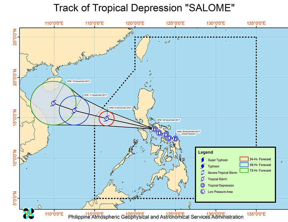
MANILA - Tropical depression "Salome" has made landfall over San Juan town, Batangas Thursday night and is expected to dump rains over parts of Luzon, state weather bureau PAGASA said.
MANILA - Tropical depression "Salome" has made landfall over San Juan town, Batangas Thursday night and is expected to dump rains over parts of Luzon, state weather bureau PAGASA said.
As of 8 p.m., PAGASA said "Salome" was spotted in the vicinity of Bulsa, San Juan town. It is packing maximum sustained winds of 55 kph near the center and gusts of up to 90 kph.
As of 8 p.m., PAGASA said "Salome" was spotted in the vicinity of Bulsa, San Juan town. It is packing maximum sustained winds of 55 kph near the center and gusts of up to 90 kph.
Signal no. 1 is raised in the following areas: Metro Manila, Bulacan, Pampanga, Southern Zambales, Rizal, Bataan, Camarines Norte, Camarines Sur, Catanduanes, Albay, Sorsogon, Masbate, Ticao and Burias Islands, Romblon, Marinduque, Quezon, Laguna, Cavite, Batangas, Oriental Mindoro, and Occidental Mindoro.
Signal no. 1 is raised in the following areas: Metro Manila, Bulacan, Pampanga, Southern Zambales, Rizal, Bataan, Camarines Norte, Camarines Sur, Catanduanes, Albay, Sorsogon, Masbate, Ticao and Burias Islands, Romblon, Marinduque, Quezon, Laguna, Cavite, Batangas, Oriental Mindoro, and Occidental Mindoro.
PAGASA warned residents in these areas, as well as those living in the eastern section of Central Luzon, of possible flash floods and landslides, as "Salome" is expected to bring strong rains.
PAGASA warned residents in these areas, as well as those living in the eastern section of Central Luzon, of possible flash floods and landslides, as "Salome" is expected to bring strong rains.
ADVERTISEMENT
The state weather bureau added that sea travel is risky over areas under storm signal no. 1 due to moderate to rough seas.
The state weather bureau added that sea travel is risky over areas under storm signal no. 1 due to moderate to rough seas.
Salome is expected to approach Metro Manila between 8 p.m. to 12 midnight, and may bring moderate to heavy rains with occasional gusty winds.
Salome is expected to approach Metro Manila between 8 p.m. to 12 midnight, and may bring moderate to heavy rains with occasional gusty winds.
"Salome" is moving west northwest at 25 kph. It is expected to exit the Philippine area of responsibility Saturday morning.
"Salome" is moving west northwest at 25 kph. It is expected to exit the Philippine area of responsibility Saturday morning.
ADVERTISEMENT
ADVERTISEMENT