'Gorio' now a typhoon, signal no.2 up in Batanes | ABS-CBN


Welcome, Kapamilya! We use cookies to improve your browsing experience. Continuing to use this site means you agree to our use of cookies. Tell me more!
'Gorio' now a typhoon, signal no.2 up in Batanes
'Gorio' now a typhoon, signal no.2 up in Batanes
Gillan Ropero,
ABS-CBN News
Published Jul 28, 2017 05:21 PM PHT
|
Updated Jul 29, 2017 07:29 AM PHT
Typhoon Gorio set to slam into Taiwan
Typhoon Gorio set to slam into Taiwan
MANILA (2nd UPDATE) - Typhoon Gorio continued to intensify Saturday morning and is expected to continue enhancing the southwest monsoon or habagat that will bring rain to parts of Luzon, the state weather bureau said.
MANILA (2nd UPDATE) - Typhoon Gorio continued to intensify Saturday morning and is expected to continue enhancing the southwest monsoon or habagat that will bring rain to parts of Luzon, the state weather bureau said.
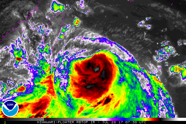
In its 5 a.m. weather bulletin, the Philippine Atmospheric Geophysical and Astronomical Services Administration (PAGASA) said Gorio is now packing maximum sustained winds of up to 145 kilometers per hour near the center and gustiness of up to 180 kph.
In its 5 a.m. weather bulletin, the Philippine Atmospheric Geophysical and Astronomical Services Administration (PAGASA) said Gorio is now packing maximum sustained winds of up to 145 kilometers per hour near the center and gustiness of up to 180 kph.
It is carrying moderate to heavy rainfall within its 500 km diameter.
It is carrying moderate to heavy rainfall within its 500 km diameter.
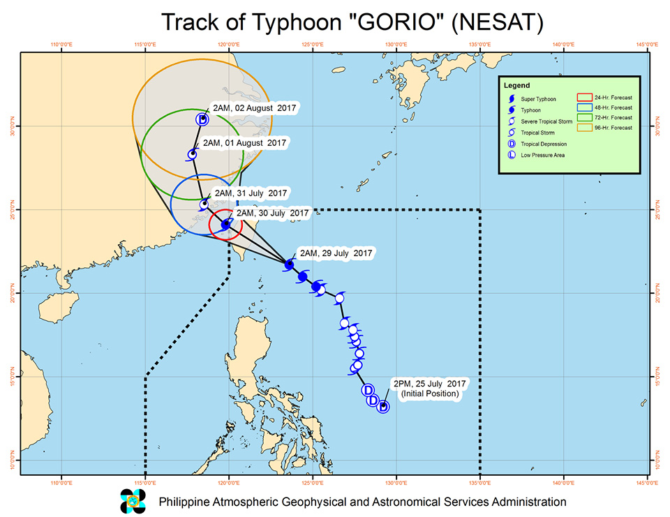
As of 4 a.m., Gorio was spotted at 200 km northeast of Basco, Batanes.
As of 4 a.m., Gorio was spotted at 200 km northeast of Basco, Batanes.
ADVERTISEMENT
Tropical Cyclone Warning Signal No. 2 remained raised in Batanes, while Tropical Cyclone Warning Signal No. 1 was declared in the Babuyan group of islands.
Tropical Cyclone Warning Signal No. 2 remained raised in Batanes, while Tropical Cyclone Warning Signal No. 1 was declared in the Babuyan group of islands.
Gorio, forecast to move northwest at 17 kph, was expected to exit the Philippine Area of Responsibility (PAR) by Sunday afternoon.
Gorio, forecast to move northwest at 17 kph, was expected to exit the Philippine Area of Responsibility (PAR) by Sunday afternoon.
Expect stormy weather over Batanes group of Islands, while rains with gusty winds will affect the Babuyan group of islands.
Expect stormy weather over Batanes group of Islands, while rains with gusty winds will affect the Babuyan group of islands.
Monsoon rains are expected over Metro Manila, Ilocos region, Central Luzon, MIMAROPA and CALABARZON. Flash floods and landslides are possible over affected areas, PAGASA added.
Monsoon rains are expected over Metro Manila, Ilocos region, Central Luzon, MIMAROPA and CALABARZON. Flash floods and landslides are possible over affected areas, PAGASA added.
The weather bureau advised fishing boats and other small seacraft not to venture out over seaboards of Northern Luzon and western seaboard of Central Luzon. It has also alerted larger sea vessels against big waves.
The weather bureau advised fishing boats and other small seacraft not to venture out over seaboards of Northern Luzon and western seaboard of Central Luzon. It has also alerted larger sea vessels against big waves.
The tropical depression sighted at the West Philippine Sea was last estimated at 560 kilometers west of Laoag City, Ilocos Norte outside PAR.
The tropical depression sighted at the West Philippine Sea was last estimated at 560 kilometers west of Laoag City, Ilocos Norte outside PAR.
Visit the ABS-CBN Weather Center for the latest weather updates.
Visit the ABS-CBN Weather Center for the latest weather updates.
ADVERTISEMENT
ADVERTISEMENT